The Overture Foundation is a collaborative open data initiative powering current and next-generation map products. Its aims are to create reliable, easy-to-use and interoperable open map data for developing geospatial applications.
In this article, we dive deep into the contrasting data models of OpenStreetMap (OSM) and Overture for their transportation network. We will discover how Overture’s Transportation network data model assures interoperability with various data sources while being customizable and suitable for developing geospatial applications.
OpenStreetMap (OSM) Sectioned Map Data Model
The OpenStreetMap (OSM) promotes community-driven mapping. Its data model requires the transportation network to be split whenever road’s attributes change, such as road type, speed limit, or lane count. This approach simplifies the editing process for mappers, preventing mixed attribute values on a section. This model also makes it easier to track the version history of each section over time.
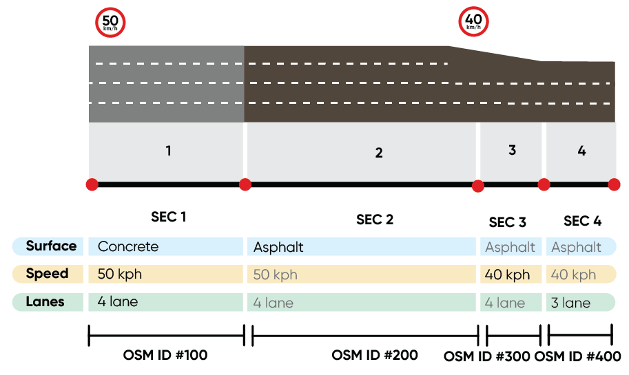 Figure 1 Example of a road with OpenStreetMap (OSM) data representation.
In Figure 1, a road with three distinct attribute changes is represented by 4 sections, each with its own identifier. While this method is beneficial for map editing, it brings several challenges for map consumers.
Suboptimal sectioning and application performance decline
Depending on the geospatial application, certain attribute changes are more crucial than others. Splitting the transportation network at every attribute change can lead to many unnecessary sections. These extra sections increase demands for the application processing and computational needs.
For routing, a network with many short sections can complicate the routing graph, having extra edges to calculate the shortest path, leading to performance decline.
In addition, OSM data model does not inherently provide the sectioning that some applications might need. Consequently, unless there is a change in attributes, roads might get extended without any sectioning at locations required by the applications.
For example, this is problematic for routing and guidance applications, which require detailed information at each decision point, especially at junctions. These applications use a network graph that sections the road at every junction, irrespective of attribute changes, for precise route time calculations and turn-by-turn directions. Consequently, preprocessing OSM data for such use cases becomes essential, adding complexity and computational demands to the application.
Identifier (ID) instability
With every split, the original section ID gets removed, and the newly introduced sections get assigned new IDs. ID changes undermine the map reliability to be referenced within different geospatial applications.
Stable map IDs are crucial for accumulating knowledge and ensuring interoperability. For instance, to aggregate traffic data, there’s a need for continuous map matching of GPS traces over time. By adding new IDs, all traces must be rematched for that period to the updated network for accurate traffic pattern analysis, which is costly for the application developers.
Similarly, in geocoding, any change to the road network ID necessitates recalculating the search index. For users, this implies that any data, analysis, or actions linked to these IDs will be lost in their application.
Ensuring the map accurately mirrors the physical world requires processing and combining large amounts of spatial data. As we add more data, the map becomes more complex and detailed. Over time, map consumers observe more attribute variations, leading to frequent ID changes.
For example, from 2018 to 2023, the number of speed limits in OSM doubled, increasing from ~8M to more than ~16M, resulting in millions of new map sections.
Data duplication and data size
When a new section gets created, not only does the new section represent the changed attribute, but also copies other attributes from the original section. This increases the data size, demanding more storage and potentially slowing down map data processing or loading.
Increased processing time compromises the map freshness while posing challenges for applications operating on devices with constrained cache storage, such as mobile phones or vehicles. For more insights on the implications of large data sizes, refer to this blog post.
Overture Linearly Referenced (LR) Data Model
The Overture Foundation is on a mission to transform the mapping industry by introducing an open, easy-to-use, and interoperable map. This initiative seeks to bring all open data sets into a singular map.
The map features are divided into 5 key categories: Base, Admin areas, Buildings, Places, and Transportation.
While OpenStreetMap (OSM) focuses on fostering a community-centric mapping environment by streamlining the map-editing process, Overture takes a different approach. Its primary goal is to cater to the specific needs of developers, enhancing the overall quality of map data and creating a map that ensures global interoperability. It is designed to enable usage across various data providers and application developers, thereby overcoming the constraints faced by other open-source maps such as OSM for commercialization.
To establish the map as a reference system, Overture Transportation network utilizes two concepts: Global Entity Reference System (GERS) and Geometric scoping, also known as Linear Referencing System (LRS). Both concepts are devised to tackle the ID stability issue resulting from the OSM data model, suboptimal sectioning of the road network, and data duplications.
In the following paragraphs, we will discuss how the implementation of these two concepts can enhance the development of geospatial applications.
The Overture Global Entity Reference System (GERS) provides a standardized method for mapping and integrating diverse datasets by assigning unique GERS IDs to specific features, such as landmarks or road sections. This system ensures interoperability by enabling various datasets representing the same feature, e.g., the Eiffel Tower in Paris, to connect easily through a common reference point. By standardizing the way data is merged, GERS enhances communication and data exchange among different data providers and developers.
Linear referencing precisely pinpoints attribute changes based on their location along linear features. This approach decouples a linear feature’s physical geometry from its attributes, preserving the continuous structure of the transportation network while allowing for attribute variations. Linear referencing has been utilized for various geospatial applications and use cases such as transportation infrastructure management, asset tracking and logistics, and traffic management. For linear referencing and how roads are divided into sections, you can read more in this blog post.
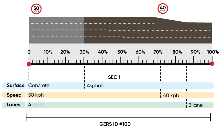 Figure 3 Example of a road with Overture Linear Referencing representation.
With OSM data model, a road section with 3 different attribute changes (e.g., speed limit, lane count, and surface) gets divided into 4 sections (see Figure 1). The same road with the linearly referenced model is represented by just one section (see Figure 3). All attribute variations are defined relative to the beginning of the section as a fraction of the sections’ length.
Overture addresses the challenges faced by application developers with the OSM data model, as outlined below.
Assuring Stable IDs
Through linear referencing, roads previously represented in OSM with multiple identifiers due to attribute changes are now unified under a single section, identified by a persistent GERS ID. The GERS ID for this section remains the same even if its attributes change.
GERS ID enhances the interoperability and integrability of the map with various datasets, ensuring a consistent and stable road network. This allows referencing the road network across various applications for knowledge development, data management, reliable editing, and proactive incident support.
Enabling optimal sectioning
Linear Referencing (LR) allows developers to section the map according to their specific needs. They can introduce sections based on specific attribute changes suited for their individual application. This leads to a map that is finely tailored to meet the specific requirements of a given application.
For instance, in routing, developers can section the map according to attribute changes such as speed limits, Functional Road Classes (FRC), and road restrictions, which are essential for the routing engine.
Reduced data footprint
Without duplicating the data, each section represents a list of various attribute changes that occur within that section. This results in more efficient representation, leading to smaller file sizes.
Linear referencing minimizes the data consumption for Over-The-Air (OTA) applications, limiting the updates to attribute updates. In contrast, the OSM data model for updating the transportation network geometry requires transferring every new section content to the client application.
Conclusion
We have highlighted the distinct approaches and practical implications of OpenStreetMap (OSM) and Overture’s data models for the transportation network.
The OSM model’s community-driven mapping approach facilitates collaboration but leads to challenges such as suboptimal sectioning of the road network, ID instability, and data duplication. These issues present considerable challenges for application developers, leading to elevated processing requirements and complications when trying to reference specific road sections due to ID instability.
In contrast, the Overture Transportation network employs Linear Referencing (LR) data model in conjunction with the Global Entity Reference System (GERS). Therefore, it aims to address the challenges identified with the OSM data model. Linear referencing enables the developers to decide, based on their application on, what attributes to section the map. By minimizing data duplication and optimizing the data representation, Overture’s model stands to reduce computational demands and data footprints, which are crucial for applications with limited storage capabilities.
What’s next?
Check the latest release of Overture map to benefit from the transportation layer linear referencing within your applications.
Join the conversation and share your valuable feedback on the schema discussion board. Help us improve and make a difference.
To learn more about Overture maps and linear referencing, please refer to this blog post.
About Overture Maps Foundation
Founded in 2022, Overture Maps Foundation is the world’s leading home for collaboration on the development of reliable, easy-to-use, and interoperable open map data that will power current and next-generation map products. This interoperable map is the basis for extensibility, enabling companies to contribute their own data. Members combine resources to build map data that is complete, accurate, and refreshed as the physical world changes. Map data will be open and extensible by all under an open data license. For more information, please visit overturemaps.org.
 Integrating TomTom APIs into the GPT Plugin Ecosystem